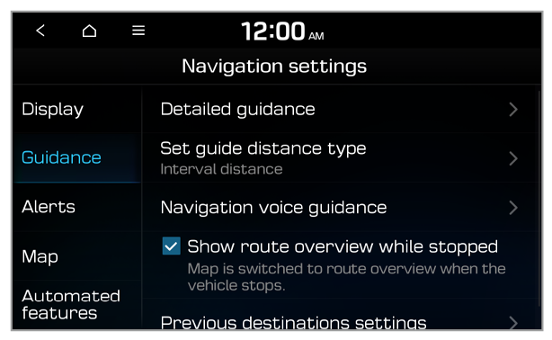
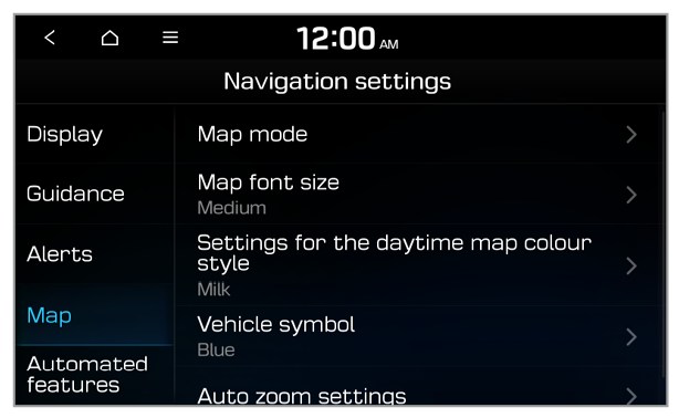
Settings

Configuring the navigation settings


You can customise various settings for navigation on the Navigation settings screen, such as navigation operation, map display, and voice guidance. You can also export or import location data.
  1. On the All menus screen, press Settings > Navigation.
  1. The Navigation settings screen will appear.
  1. Select an option to change.

Display

You can set the details of the information to display on the map.

Vehicle speed

You can set the system to display the vehicle speed on the map.

Traffic info

You can set the system to display nearby traffic information on the map.

Colour for traffic on the route

You can set the system to display the route in different colors to indicate the traffic conditions.

Nearby POI

You can select POI categories to display on the map.

Information (if equipped)

You can set the information to display on the map while driving.
  • Colour for traffic on the route: Display the route with different colours according to traffic conditions.
  • Display vehicle speed: Display the vehicle speed on the map.
  • Show route details: Display additional information, such as driving directions or lane changes.
  • Show speed limits: Set whether to display the speed limits on the screen.
  • Display guidance information on top of screen: Set to briefly display navigation guidance at the top of the screen when not on the map screen.

Return to map (if equipped)

You can set the system to return to the map screen from the radio/media screen after a set period of time.
Note
  • The map return timer will only function when you are driving with a set destination.
  • This feature is not available when phone projection is active.

Automatic return after scrolling (if equipped)

You can set to return to your current location automatically after you move to another location by swiping on the map.

Guidance

You can configure the navigation guidance settings.

Detailed guidance

You can set the details of the navigation guidance.
  • Show route details: Display additional information, such as driving directions or lane changes.
  • Show speed limits: Set whether to display the speed limits on the screen.
  • Display guidance information on top of screen: Set to briefly display navigation guidance at the top of the screen when not on the map screen.

Set guide distance type

You can configure settings for displaying the distance to the destination during guidance.
  • Interval distance: Set to display the distance as the distance between turns.
  • Cumulative distance: Set to display the distance as the distance from the current position to each turn.

Navigation voice guidance

You can configure the navigation guidance functions.
  • Mute voice navigation nearby destination: Set to end voice guidance near the destination if the destination is saved in the address book.

Show route overview while stopped

You can set the route overview to be displayed on the navigation screen when your vehicle is stationary.

Previous destinations settings

You can set whether to save your previous destinations automatically and view previous destinations when the navigation starts up.
  • Save previous destinations: Set to save your destinations automatically.
  • Show previous destinations on start: Set to view previous destinations when the navigation starts up.

Alerts

You can set to activate drive assist features when needed for safety.

Camera alert settings

You can set when to receive alerts for traffic enforcement cameras.
  • Alert distance depending on the speed limit: Set the timing of alerts to be set automatically according to your driving speed.
  • Alert distance (General): This option is available when you deactivate the Alert distance depending on the vehicle speed option. Set when to receive camera alerts on public roads.
  • Alert distance (Motorway): This option is available when you deactivate the Alert distance depending on the vehicle speed option. Set when to receive camera alerts on motorways.

Safety alert

You can select types of safety alerts and when to receive alerts (day/night).

Map

You can change the settings for the map display.

Map mode

You can customise the map details.
  • Map view: Set the default view mode of the map screen.
  • 2D North up: North is always up.
  • 2D heading up: The map rotates according to your driving direction.
  • 3D heading up: A three-dimension effect is applied and the map rotates according to your driving direction.
  • 3D buildings: Set to display nearby buildings.
  • Auto zoom: Set the map scale to change automatically according to driving conditions or manually.
  • Display traffic information (if equipped): Set to display nearby traffic information on the map.

Map font size

You can set the size of the text on the map.

Settings for the daytime map colour style

You can set the colour scheme of the map.

Vehicle symbol

You can select a vehicle symbol to indicate your current location on the map.

Auto zoom settings

You can select the scale of the map for each speed section.
Note
For example, when you select 100 m for the 20~49 km/h zone and 200 m for the 50~79 km/h zone, the unit interval for the map scale becomes 100 m when the vehicle speed is 49 km/h and 200 m when the vehicle speed is 50 km/h.

POI display (if equipped)

You can select POI categories to display on the map.

Automated features

You can change navigation-related settings, such as exporting or importing location data.

Automatic return after scrolling

You can set to return to your current location automatically after you move to another location by swiping on the map.

Return to map

You can set the system to return to the map screen from the radio/media screen after a set period of time.
Note
  • The map return timer will only function when you are driving with a set destination.
  • This feature is not available when phone projection is active.

My data

You can import or export location data via a USB device.
  • Import favourites/previous destinations from USB: Import location data from a USB storage device.
Note
  • Data previously imported to the system will be deleted.
  • If you import data that uses different coordinates, the locations of the imported places may be altered.
  • Export favourites/previous destinations to USB: Export your location data to a USB storage device.
Note
Data previously exported to the USB device will be deleted.
Note
For importing and exporting location data, use only USB storage devices formatted in FAT16/32 format.

Satellite

You can view GPS satellite status and the coordinates of your current location.

Previous destinations settings (if equipped)

You can set whether to save your previous destinations automatically and view previous destinations when the navigation starts up.
  • Save previous destinations: Set to save your destinations automatically.
  • Show previous destinations on start: Set to view previous destinations when the navigation starts up.