Navigation
This menu describes navigation settings. Some functions and images may differ from the actual product, according to the model, option and country.
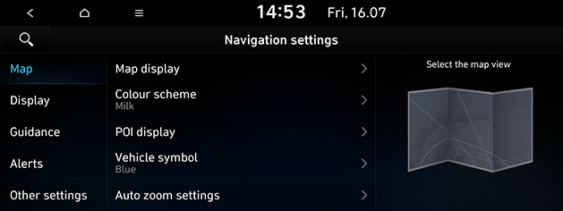
Map
This menu is used to change the map view settings.
- Press [SETUP] > [Navigation] > [Map].
|
|
- Select the desired items.
- [Map display]: Sets the type of the map.
- [Map view]: Sets the map view style.
- [Display traffic information]: Turns the traffic information on the map on or off.
- [3D buildings]: Sets whether to display 3D buildings in the 3D map view.
- [Auto zoom]: Sets whether to adjust the scale automatically.
- [Colour scheme]: Sets the map colour.
- [POI display]: Selects the POI information to display on the map.
- [Vehicle symbol]: Sets the vehicle symbol style.
- [Auto zoom settings]: Sets the map scale to be adjusted automatically based on the vehicle speed.
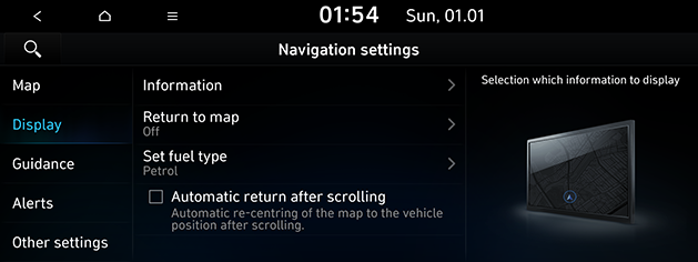
Display
This menu is used to change the display environment settings.
- Press [SETUP] > [Navigation] > [Display].
|
|
- Select the desired items.
- [Information]: Sets the information and notifications to display.
- [Colour for traffic on the route]: Check or uncheck to show or hide traffic problems along the route in a special colour on the map.
- [Display vehicle speed]: Sets to display vehicle speed. In some models of the vehicles, the GPS speed is displayed and it may differ from the clustering speed.
- [Show route details]: Sets the detailed location guide display.
- [Show speed limits]: Sets the speed limits display.
- [Return to map]: After the selected time, the system automatically switches from radio/media to the navigation map screen, if a route is active.
- [Set fuel type]
- [Display Fuel Price Info on Map]: Sets whether display fuel prices for stations under the average fuel price.
- [Fuel type]: Sets the desired fuel type.
- [Automatic return after scrolling]: Automatically returns to the vehicle position on the map after scrolling.
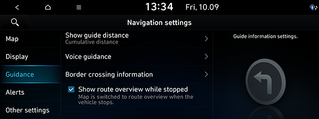
Guidance
This menu is used to change the guidance settings.
- Press [SETUP] > [Navigation] > [Guidance].
|
|
- Select the desired items.
- [Show guide distance]: Sets the distance display method to the guidance position to [Interval distance] or [Cumulative distance].
- [Voice guidance]: Sets whether to execute the pronounce street name or not.
- [Border crossing information]
- [Country information]: Displays country information based on the current location.
- [Border crossing information]: Sets whether to display the border crossing information or not.
- [Show route overview while stopped]: Sets route overview to be displayed while stopping.
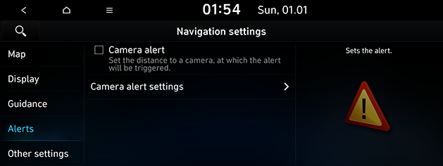
Alerts
This menu is used to change the camera alert settings. This function is available only when Bluelink is activated or the Wi-Fi network is connected.
- Press [SETUP] > [Navigation] > [Alerts].
|
|
- Select the desired items.
- [Camera alert]: Sets the camera alert enable.
- [Camera alert settings]: Adjusts camera alert settings.
- [Alert distance depending on the vehicle speed]: Sets the alert distance depending on the speed limit.
- [Alert distance (General)]: Sets the alert distance in the general road.
- [Alert distance (Motorway)]: Sets the alert distance in the motorway.
Other settings
- Press [SETUP] > [Navigation] > [Other settings].
|
|
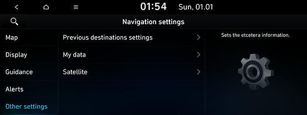
- Select the desired item.
- [Previous destinations settings]
- [Save previous destinations]: Selects to automatically save a location in previous destinations.
- [Save time stamp in previous destinations]: Sets to save the time you used the previous destinations.
- [Show previous destinations on start]: Selects to show previous destinations after navigation starts up.
- [Recommended destinations]: Sets whether to display recommended destination.
- [My data]
- [Import saved places/previous destinations from USB]: This function is used to import the address book and previous destinations in the USB device to the navigation system.
- [Export saved places/previous destinations to USB]: This function is used to export the address book and previous destinations in the navigation system to the USB device.
- [Satellite]: Displays the satellite status.
|
,Note |
|